Rhode Island destinations, parks and attractions
Are you going on a beach road trip to Rhode Island, looking for tips about the destinations so you and your party can enjoy it, be comfortable and not spend a fortune?
Here are some of the top beach destinations in Rhode Island and tips about visiting them
Rhode Island State Beaches
- Parking Rates
- Season Dates
- Buy Your Pass Online
- Parking Lot Status
- Gift Certificates
- 4x4 Pass
- Frequently Asked Questions
Questions? Contact RI State Parks staff at 401-667-6200 or DEM.RIparks@dem.ri.gov. Need
- State Beach Parking - Check here for the near real-time status of parking lots at our busiest state beaches. Instructions for Purchasing RI State Beach Passes Online
-
Saltwater Beaches
The Ocean State has beautiful state beaches, each with its own unique charm and amenities. Whether you're into swimming, sunbathing, building sandcastles, picnicking or people-watching, there's a lovely spot just waiting for you. So, grab your sunscreen and enjoy! See this page for details about each Rhode Island beach listed below.
- Charlestown Breachway - Map and directions. Charlestown Beach Road, Charlestown. This golden sand beach offers a panoramic view of Block Island Sound and is known as one of the best salt water fishing areas in South County.
- East Beach - Map and directions. East Beach Road, Charlestown. The least developed of the state beaches, with limited parking and a half dozen changing rooms, East Beach is one of RI’s spectacular seaside treasures.
- East Matunuck - Map and directions. 950 Succotash Road, South Kingstown. Noted for its strong surf, East Matunuck State Beach totals almost 150 acres and sports a modern beach pavilion with hot showers and concessions.
- Misquamicut - Map and directions. 257 Atlantic Avenue, Westerly. One of the state's most popular beaches with over a half mile of beach front, Misquamicut State Beach features a modern pavilion, playground, and shade gazebos.
- Roger Wheeler - Map and directions. 100 Sand Hill Cove Road, Narragansett. Popular among families with small children, this beach features a playground and modern beach pavilion and an environmental educational area with local marine animals.
- Salty Brine - Map and directions. 254 Great Island Road, Narragansett. Salty Brine State Beach is a tiny beach, barely 100 yards long, with gentle surf set close to the busy Galilee docks and several seafood restaurants.
- Scarborough North - Map and directions. 970 Ocean Road, Narragansett. Scarborough North features a large parking area, pavilion with concessions, shaded shelters, boardwalk, and an observation tower.
- Scarborough South - Map and directions. 970 Ocean Road, Narragansett. Adjacent to Scarborough North, Scarborough South adds an additional 16 acres with over 1,000 feet of beach frontage.
Freshwater and Non-Surf Saltwater Beaches
- Burlingame Picnic Area - Map and directions. Sanctuary Road, Charlestown. This popular freshwater swimming area on Watchaug Pond offers picnic area, beach, and a nearby boat launch for boating and fishing.
- Fort Adams State Park - Park maps. Harrison Avenue, Newport. Situated at the mouth of the Newport Harbor, Fort Adams State Park offers saltwater swimming with panoramic views of Narragansett Bay.
- Goddard Memorial State Park - Park maps. Ives Road, Warwick. Visitors to Goddard Memorial State Park can enjoy saltwater swimming and fishing at the public beach.
- Lincoln Woods State Park - Park maps. Manchester Print Works Road, Lincoln. Enjoy freshwater swimming at Olney Pond with a modern beach pavilion that features hot showers, restrooms, and food concessions.
- Pulaski State Park - Park maps. Pulaski Road, Chepachet. Nestled within the George Washington Management Area, this 13-acre recreational area offers trout fishing and swimming at Peck Pond
- There are no fees to access beaches within state parks. Lifeguards are usually on duty seasonally from 9:00 AM to 5:00 PM.
Rhode Island Seasons, bugs, topography and climate
Rhode Island has humid, warm summers and cold, less humid winters. The lowest recorded temperature in Rhode Island was −23 °F (−31 °C) on February 5, 1996, in Greene. Monthly average temperatures range from a high of 83 °F (28 °C) to a low of 20 °F (−7 °C).!
Rhode Island Camping tips
Rhode Island DEM's Division of Parks and Recreation manages 8,200 acres of land, including parks, beaches, campgrounds, bike paths, historic sites, picnic areas, trails, athletic fields, and fishing access.
There are both state parks and private campgrounds in Rhode Island.
Campgrounds
 Burlingame - Map.
1 Burlingame Park Road, Charlestown. Situated next to
Watchaug Pond, this spacious campground features 700 rustic campsites, as well as 20 rustic cabins. LEARN MORE
Burlingame - Map.
1 Burlingame Park Road, Charlestown. Situated next to
Watchaug Pond, this spacious campground features 700 rustic campsites, as well as 20 rustic cabins. LEARN MORE Charlestown Breachway - Map.
Charlestown Beach Road, Charlestown. Camp along the
breachway with spectacular ocean views and some of Rhode Island's best saltwater fishing. LEARN MORE
Charlestown Breachway - Map.
Charlestown Beach Road, Charlestown. Camp along the
breachway with spectacular ocean views and some of Rhode Island's best saltwater fishing. LEARN MORE East Beach - Map.
East Beach Road, Charlestown. Specialty camping at
East Beach is offered in two areas that can only be accessed by 4-wheel drive vehicles. LEARN MORE
East Beach - Map.
East Beach Road, Charlestown. Specialty camping at
East Beach is offered in two areas that can only be accessed by 4-wheel drive vehicles. LEARN MORE Fishermen's Memorial - Map.
1011 Point Judith Rd., Narragansett. Camping in a
"seaside village" atmosphere, complete with neatly trimmed grass, tree lined paths and activities for the entire
family. LEARN MORE
Fishermen's Memorial - Map.
1011 Point Judith Rd., Narragansett. Camping in a
"seaside village" atmosphere, complete with neatly trimmed grass, tree lined paths and activities for the entire
family. LEARN MORE George Washington - Map.
2185 Putnam Pike, Chepachet. Enjoy forest camping
overlooking Bowdish Reservoir with a multitued of opportunities to enjoy the outdoors. LEARN MORE
George Washington - Map.
2185 Putnam Pike, Chepachet. Enjoy forest camping
overlooking Bowdish Reservoir with a multitued of opportunities to enjoy the outdoors. LEARN MORE
 Portable Power Bank 50,000 mah, Ultra-High Capacity Battery Pack,2 USB Output High Speed Charging Power bank
 Portable Camping LED Light and Fan, 40hrs Rechargeable Battery w Hanging Hook for Tent, Car, RV, outages, etc.
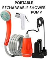 Portable Shower Pump - Rechargeable Battery, w/Shower Head and Handheld Sprayer
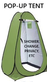 Pop Up Instant Portable Tent -
For changing, showers, Toilet, Rain Shelter with Window for Beach Easy Set Up, Foldable with Carry Bag, Lightweight and Sturdy
Pop Up Instant Portable Tent -
For changing, showers, Toilet, Rain Shelter with Window for Beach Easy Set Up, Foldable with Carry Bag, Lightweight and Sturdy OlimpiaFit Quick Dry Towel - Fast Drying Lightweight Microfiber Travel Towels w/Bag for Camping, Beach, Gym, Backpacking, Sports, Yoga, Swim
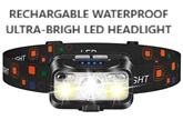 Headlamp - 1200 Lumen Super Bright, Rechargeable, Motion Sensor, 2-Pack, Waterproof w White Red Light in 8 Modes
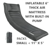 Camping mattress -
Super-comfortable, mattress, with Pillow, Thick 6 Inch Ultralight Sleeping Pad with Built-in Pump
Camping mattress -
Super-comfortable, mattress, with Pillow, Thick 6 Inch Ultralight Sleeping Pad with Built-in Pump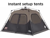 Coleman Camping Tent with 60 second Instant Setup, for 4, 6, 8, 10 people; Weatherproof Double-Thick Fabric and Included Carrying
bag
Coleman Camping Tent with 60 second Instant Setup, for 4, 6, 8, 10 people; Weatherproof Double-Thick Fabric and Included Carrying
bag